Nauka i tehnologija

Re: Nauka i tehnologija
Ma nije ovo tačno, rek'o Trump
-
Delija

- Postovi: 18945
- Pridružio se: 13 Jan 2012, 08:48
- Garaža: BMW M340i | Honda CR-V
- Lokacija: NS
- Kontakt:
Re: Nauka i tehnologija
Ma da... Zato mi je u Groningenu u avgustu bilo 8 stepenipassenger je napisao:Nešto nije kako treba. Alpi, a 16-17 stepeni u 5-6 ujutru, a sad će decembar
Life is not measured by the number of breaths you take but by the moments that take your breath away...
-
maxer

- Postovi: 6672
- Pridružio se: 13 Jan 2012, 01:36
- Garaža: Ford Focus II Mk2 1.6 16V
- Lokacija: Zaječar
Re: Nauka i tehnologija
The 2000 Year-Old Computer - Decoding the Antikythera Mechanism (2012)
Odličan dokumentarac , ja sam ga tek sada odgledao, o verovarno najvećem naučnom dostignuću antičkog doba: mašini koja je pokazivala kretanje tada poznatih nebeskih tela i još mnogo toga.
Do skoro nije postojala ni naznaka da su ovako nešto znali/mogli da naprave ali jesu, samo što su skoro svi tragovi (osim ovog jednog) uništeni u potonjim ratovima/osvajanjima od strane Rimljana i Arapa.
https://www.youtube.com/watch?v=nZXjUqLMgxM
Odličan dokumentarac
Do skoro nije postojala ni naznaka da su ovako nešto znali/mogli da naprave ali jesu, samo što su skoro svi tragovi (osim ovog jednog) uništeni u potonjim ratovima/osvajanjima od strane Rimljana i Arapa.
https://www.youtube.com/watch?v=nZXjUqLMgxM
-
maxer
- Postovi: 6672
- Pridružio se: 13 Jan 2012, 01:36
- Garaža: Ford Focus II Mk2 1.6 16V
- Lokacija: Zaječar
Re: Nauka i tehnologija
Najnoviji snimci (poenta je u održavanju ravnoteže u realnom vremenu, baš kao čovek):
https://www.youtube.com/watch?v=_5PtxHsr038
Ovo je iz februara:
https://www.youtube.com/watch?v=rVlhMGQgDkY
https://www.youtube.com/watch?v=_5PtxHsr038
Ovo je iz februara:
https://www.youtube.com/watch?v=rVlhMGQgDkY
-
maxer
- Postovi: 6672
- Pridružio se: 13 Jan 2012, 01:36
- Garaža: Ford Focus II Mk2 1.6 16V
- Lokacija: Zaječar
Re: Nauka i tehnologija
Vest je iz januara 2016. ali tek sada naiđoh na nju LINK:
Antarktik: slika koju je objavila NASA, pokazuje tragove mogućeg ljudskog naselja, prekrivenog sa 2.3 km debelim slojem leda
Antarctica: NASA Images Reveal Traces of Ancient Human Settlement Underneath 2.3 km of Ice
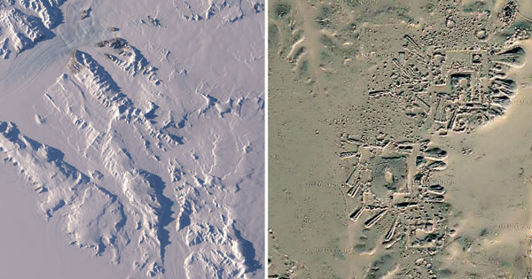
WASHINGTON | Recently released remote sensing photography of NASA’s Operation IceBridge mission in Antarctica led to a fascinating discovery when images revealed what some experts believe could be the existence of a possible ancient human settlement lying beneath an impressive 2.3 kilometers of ice.
The intriguing discovery was made during aircraft tests trials of NASA’s Advanced Topographic Laser Altimeter System (ATLAS) lidar technology set to be launched on the Ice, Cloud and land Elevation Satellite-2 (ICESat-2) in 2017, that aims to monitor changes in polar ice.
“There’s very little margin for error when it comes to individual photons hitting on individual fiber optics, that is why we were so surprised when we noticed these abnormal features on the lidar imagery,” explains Nathan Borrowitz, IceBridge’s project scientist and sea ice researcher with NASA’s Goddard Space Flight Center in Greenbelt, Maryland.
“As of now we can only speculate as to what these features are but the launching of ICESat-2 in 2017 could lead to other major discoveries and a better understanding of Antarctica’s geomorphological features” he adds.

Although NASA scientist Nathan Borrowitz claims the infrared images are definitely intriguing, other experts claim they are clearly the proof of ancient human engineering
A human settlement buried under 2.3 km of ice
Leading archeologist, Ashoka Tripathi, of the Department of Archaeology at the University of Calcutta believes the images show clear evidence of an ancient human settlement beneath the ice sheet.
“These are clearly features of some sort of human-made structure, resembling some sort of pyramidal structure. The patterns clearly show nothing we should expect from natural geomorphological formations found in nature. We clearly have here evidence of human engineering. The only problem is that these photographs were taken in Antarctica under 2 kilometers of ice. That is clearly the puzzling part, we do not have any explanation for this at the moment,” he admits.
“These pictures just reflect a small portion of Antarctica’s total land mass. There are possibly many other additional sites that are covered over with ice. It just shows us how easy it is to underestimate both the size and scale of past human settlements,” says Dr Tripathi.
Remnants of a lost civilization
Historian and cartographer at the University of Cambridge, Christopher Adam, believes there might be a rationnal explanation.
“One of histories most puzzling maps is that of the Turkish admiral Piri Reis in 1513 AD which successfully mapped the coastline of Antarctica over 500 years ago.
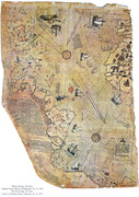
What is most fascinating about this map is that it shows the coastline of Antarctica without any ice. How is this possible when images of the subglacial coastline of Antarctica were only seen for the first time after the development of ground-penetrating radar in 1958? Is it possible Antarctica has not always been covered under such an ice sheet? This could be evidence that it is a possibility” he acknowledges.
« A slight pole shift or displacement of the axis of rotation of the Earth in historical times is possibly the only rational explanation that comes to mind but we definitely need more research done before we jump to any conclusion.”
ICESat-2 (Ice, Cloud, and land Elevation Satellite 2), part of NASA’s Earth Observing System, is a planned satellite mission for measuring ice sheet mass elevation, sea ice freeboard as well as land topography and vegetation characteristics, and is set to launch in may 2017.
Antarktik: slika koju je objavila NASA, pokazuje tragove mogućeg ljudskog naselja, prekrivenog sa 2.3 km debelim slojem leda
Antarctica: NASA Images Reveal Traces of Ancient Human Settlement Underneath 2.3 km of Ice
WASHINGTON | Recently released remote sensing photography of NASA’s Operation IceBridge mission in Antarctica led to a fascinating discovery when images revealed what some experts believe could be the existence of a possible ancient human settlement lying beneath an impressive 2.3 kilometers of ice.
The intriguing discovery was made during aircraft tests trials of NASA’s Advanced Topographic Laser Altimeter System (ATLAS) lidar technology set to be launched on the Ice, Cloud and land Elevation Satellite-2 (ICESat-2) in 2017, that aims to monitor changes in polar ice.
“There’s very little margin for error when it comes to individual photons hitting on individual fiber optics, that is why we were so surprised when we noticed these abnormal features on the lidar imagery,” explains Nathan Borrowitz, IceBridge’s project scientist and sea ice researcher with NASA’s Goddard Space Flight Center in Greenbelt, Maryland.
“As of now we can only speculate as to what these features are but the launching of ICESat-2 in 2017 could lead to other major discoveries and a better understanding of Antarctica’s geomorphological features” he adds.
Although NASA scientist Nathan Borrowitz claims the infrared images are definitely intriguing, other experts claim they are clearly the proof of ancient human engineering
A human settlement buried under 2.3 km of ice
Leading archeologist, Ashoka Tripathi, of the Department of Archaeology at the University of Calcutta believes the images show clear evidence of an ancient human settlement beneath the ice sheet.
“These are clearly features of some sort of human-made structure, resembling some sort of pyramidal structure. The patterns clearly show nothing we should expect from natural geomorphological formations found in nature. We clearly have here evidence of human engineering. The only problem is that these photographs were taken in Antarctica under 2 kilometers of ice. That is clearly the puzzling part, we do not have any explanation for this at the moment,” he admits.
“These pictures just reflect a small portion of Antarctica’s total land mass. There are possibly many other additional sites that are covered over with ice. It just shows us how easy it is to underestimate both the size and scale of past human settlements,” says Dr Tripathi.
Remnants of a lost civilization
Historian and cartographer at the University of Cambridge, Christopher Adam, believes there might be a rationnal explanation.
“One of histories most puzzling maps is that of the Turkish admiral Piri Reis in 1513 AD which successfully mapped the coastline of Antarctica over 500 years ago.
What is most fascinating about this map is that it shows the coastline of Antarctica without any ice. How is this possible when images of the subglacial coastline of Antarctica were only seen for the first time after the development of ground-penetrating radar in 1958? Is it possible Antarctica has not always been covered under such an ice sheet? This could be evidence that it is a possibility” he acknowledges.
« A slight pole shift or displacement of the axis of rotation of the Earth in historical times is possibly the only rational explanation that comes to mind but we definitely need more research done before we jump to any conclusion.”
ICESat-2 (Ice, Cloud, and land Elevation Satellite 2), part of NASA’s Earth Observing System, is a planned satellite mission for measuring ice sheet mass elevation, sea ice freeboard as well as land topography and vegetation characteristics, and is set to launch in may 2017.
-
maxer
- Postovi: 6672
- Pridružio se: 13 Jan 2012, 01:36
- Garaža: Ford Focus II Mk2 1.6 16V
- Lokacija: Zaječar
Re: Nauka i tehnologija
Uvek sam imao veliko poštovanje za Mašinsku tehnologiju i "mašince" ... to je suština ljudske industrije tj. civilizaicje. Bez toga bi smo bili na nivou srednjeg veka.
Koliko kompleksnog znanja treba da se ovako nešto smisli, proračuna, napravi i upotrebi
https://www.youtube.com/watch?v=UFNEqY6nn0g
Koliko kompleksnog znanja treba da se ovako nešto smisli, proračuna, napravi i upotrebi
https://www.youtube.com/watch?v=UFNEqY6nn0g

Re: Nauka i tehnologija
maxer je napisao:Vest je iz januara 2016. ali tek sada naiđoh na nju LINK:
Antarktik: slika koju je objavila NASA, pokazuje tragove mogućeg ljudskog naselja, prekrivenog sa 2.3 km debelim slojem leda
Antarctica: NASA Images Reveal Traces of Ancient Human Settlement Underneath 2.3 km of Ice
WASHINGTON | Recently released remote sensing photography of NASA’s Operation IceBridge mission in Antarctica led to a fascinating discovery when images revealed what some experts believe could be the existence of a possible ancient human settlement lying beneath an impressive 2.3 kilometers of ice.
The intriguing discovery was made during aircraft tests trials of NASA’s Advanced Topographic Laser Altimeter System (ATLAS) lidar technology set to be launched on the Ice, Cloud and land Elevation Satellite-2 (ICESat-2) in 2017, that aims to monitor changes in polar ice.
“There’s very little margin for error when it comes to individual photons hitting on individual fiber optics, that is why we were so surprised when we noticed these abnormal features on the lidar imagery,” explains Nathan Borrowitz, IceBridge’s project scientist and sea ice researcher with NASA’s Goddard Space Flight Center in Greenbelt, Maryland.
“As of now we can only speculate as to what these features are but the launching of ICESat-2 in 2017 could lead to other major discoveries and a better understanding of Antarctica’s geomorphological features” he adds.
Although NASA scientist Nathan Borrowitz claims the infrared images are definitely intriguing, other experts claim they are clearly the proof of ancient human engineering
A human settlement buried under 2.3 km of ice
Leading archeologist, Ashoka Tripathi, of the Department of Archaeology at the University of Calcutta believes the images show clear evidence of an ancient human settlement beneath the ice sheet.
“These are clearly features of some sort of human-made structure, resembling some sort of pyramidal structure. The patterns clearly show nothing we should expect from natural geomorphological formations found in nature. We clearly have here evidence of human engineering. The only problem is that these photographs were taken in Antarctica under 2 kilometers of ice. That is clearly the puzzling part, we do not have any explanation for this at the moment,” he admits.
“These pictures just reflect a small portion of Antarctica’s total land mass. There are possibly many other additional sites that are covered over with ice. It just shows us how easy it is to underestimate both the size and scale of past human settlements,” says Dr Tripathi.
Remnants of a lost civilization
Historian and cartographer at the University of Cambridge, Christopher Adam, believes there might be a rationnal explanation.
“One of histories most puzzling maps is that of the Turkish admiral Piri Reis in 1513 AD which successfully mapped the coastline of Antarctica over 500 years ago.
What is most fascinating about this map is that it shows the coastline of Antarctica without any ice. How is this possible when images of the subglacial coastline of Antarctica were only seen for the first time after the development of ground-penetrating radar in 1958? Is it possible Antarctica has not always been covered under such an ice sheet? This could be evidence that it is a possibility” he acknowledges.
« A slight pole shift or displacement of the axis of rotation of the Earth in historical times is possibly the only rational explanation that comes to mind but we definitely need more research done before we jump to any conclusion.”
ICESat-2 (Ice, Cloud, and land Elevation Satellite 2), part of NASA’s Earth Observing System, is a planned satellite mission for measuring ice sheet mass elevation, sea ice freeboard as well as land topography and vegetation characteristics, and is set to launch in may 2017.
Da li je tacan podatak da je zabranjeno izvoditi ekspedicije na Antarktiku?

-
maxer
- Postovi: 6672
- Pridružio se: 13 Jan 2012, 01:36
- Garaža: Ford Focus II Mk2 1.6 16V
- Lokacija: Zaječar
Re: Nauka i tehnologija
Ne.
Odakle ti to?
Odakle ti to?
-
maxer
- Postovi: 6672
- Pridružio se: 13 Jan 2012, 01:36
- Garaža: Ford Focus II Mk2 1.6 16V
- Lokacija: Zaječar
Re: Nauka i tehnologija
To ne znam ... ali znam jedno: to je ravno samoubistvu!
Ne postoji negostoljubiviji-smrtonosniji deo na planeti od Antarktika. Tamo je -50 "normalna temp." a noću kako gde i ovisno o god.dobu, ide i do -100C.
Pogledaj ovo na primer (namestio sam da počne od 33:07), Mullens Valley:
https://youtu.be/UnXJxZva4Es?t=33m7s
Ne postoji negostoljubiviji-smrtonosniji deo na planeti od Antarktika. Tamo je -50 "normalna temp." a noću kako gde i ovisno o god.dobu, ide i do -100C.
Pogledaj ovo na primer (namestio sam da počne od 33:07), Mullens Valley:
https://youtu.be/UnXJxZva4Es?t=33m7s
-
Mladen7

- Postovi: 2129
- Pridružio se: 10 Jul 2014, 17:11
- Garaža: Alfa Romeo 159 1.9 JTDm 16v Sportwagon
- Lokacija: Beograd ,NBg
Re: Nauka i tehnologija
@ sebekkg
Nekoliko ekspedicija u daljoj prošlosti, mada ug to je sve na rubnim delovima.
Ozbiljne i vrlo čudne(s obzirom na količinu i obim vojnih snaga) ekspedicije je posle 2. S rata organizovala SAD ,pod vodstvom Admirala Birda(imao je i jednu pre rata).
https://en.wikipedia.org/wiki/Operation_Highjump
https://en.wikipedia.org/wiki/Operation_Deep_Freeze
Posle ovoga, dolazi do sporazuma koji si pominjao:
https://en.wikipedia.org/wiki/Antarctic_Treaty_System
To oko temperatura mi je vrlo čudno otkud tolika razlika u odnosu na Artik, ok jasno kada je na sev. leto ali zar sad kada je na jugu leto a ovde zima temp na Antartiku bi trebala biti barem slična kao na Artiku-kada je leto kod ˝nas˝.
Poslednja izmena od Mladen7 u 19 Dec 2016, 19:13, izmenjeno 1 put ukupno.
-
maxer
- Postovi: 6672
- Pridružio se: 13 Jan 2012, 01:36
- Garaža: Ford Focus II Mk2 1.6 16V
- Lokacija: Zaječar
Re: Nauka i tehnologija
Sva istraživanja i ekspedicije se na Antarktiku rade samo "leti" tj. sada kada je kod nas zima. Naravno da su tada temp. više ali generalno gledano Južni pol je mnogo hladnije mesto nego Severni. Severni pol je voda a Južni je kopno i to više od 1.5x veće od USA. Tamo postoje delovi sa 3000 met. nadm. visine.
Re: Nauka i tehnologija
Mene je taj podatak da je ovaj amerikanac isao sa tolikom vojskom isao na ekspediciju i davao neke cudne intervjue, a da se posle potpise taj pakt koji Mladen spominje, zaista zaintrigirao.
Sent from my SM-N9005
Sent from my SM-N9005

Re: Nauka i tehnologija
Baš je pre neki dan bilo 100 godina od kada je Norvežanin Roald Amundsen sa svojom ekspedicijom "osvojio" južni pol. Ovaj ugovor o tome kako neće polagati prava na Antarktik su potpisali SSSR i SAD, ali su zato Argentina i Novi Zeland obeležili neke manje delove kao svoje. A najjača od svih je Norveška, koja je "osvojila" skoro pola ovog kontinenta.  Pri tome nije reč o zemlji sa juga južne polulopte, kao što su ove dve, već naprotiv, sa severa severne.
Da, ekspedicije se vrše u ovo doba godine, kada na južnoj polulopti počinje leto. Tada temperatura na Antarktiku bude samo oko -40. Najniža je izmerena u sovjetskoj istraživačkoj stanici Vostok (pretpostavljam zimi) i iznosi -82.8.
--------
Inače, najniža temperatura u stalno naseljenom mestu je izmerena u istočnom Sibiru, u gradu (zapravo selu, ali ima status grada) Verhojansk i iznosi -67.8.
Ђенерал Јанковић
-
maxer
- Postovi: 6672
- Pridružio se: 13 Jan 2012, 01:36
- Garaža: Ford Focus II Mk2 1.6 16V
- Lokacija: Zaječar
Re: Nauka i tehnologija
https://www.youtube.com/watch?v=Dsf3N_dt1yc
A new record of -94.7C recorded in eastern Antarctica in August of 2010, but only reported last month. That’s more than five degrees colder than Vostok Station was.
https://www.theweathernetwork.com/news/ ... arth/19302
A new record of -94.7C recorded in eastern Antarctica in August of 2010, but only reported last month. That’s more than five degrees colder than Vostok Station was.
https://www.theweathernetwork.com/news/ ... arth/19302
Poslednja izmena od maxer u 19 Dec 2016, 21:33, izmenjeno 1 put ukupno.